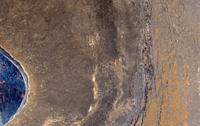
THIS IS NOT A PHOTOGRAPH. 😉 – Screenshot of a zoom in the orthophoto of the Nyiragongo crater, recently produced thanks to photographs acquired from a helicopter, in July 2014. (Image acquisition realized with the support of Nikon BeLux)
[FR] Grâce aux photographies récoltées par hélicoptère en juillet 2014 (et grâce à un léger changement de stratégie dans le traitement des données), j’ai le plaisir d’annoncer la sortie d’un premier modèle numérique de terrain (MNT) du cratère principal du Nyiragongo.
Ce MNT a été produit à une résolution de 58 cm et couvre la majeure partie du cratère. Seules les parties cachées par le panache de gaz volcanique et le haut des flancs supérieurs n’ont pas été modélisés.
Le MNT est accompagné d’une orthophoto produite à une résolution de 15 cm. Les détails dans cette image (voir photo) sont à couper le souffle. Grâce à ces deux images nouvellement produites, je vais enfin pouvoir clôturer un des objectifs majeurs de ma thèse. … à 3 mois de la fin, il était temps ! 🙂
—————
[EN] Thanks to photos acquired from a helicopter, in July 2014, (and thanks to small changes in the processing strategy) I have the pleasure to announce the release of a first digital elevation model (DEM) of the Nyiragongo main crater.
This DEM has a spatial resolution of 58 cm and covers almost all the main parts of the crater. Only parts hidden by the volcanic gas plume and the upper flanks were not modeled.
The DEM comes with an orthophoto, which has a spatial resolution of 15 cm. Details in this image (see photo) are breathtaking. Thanks to these two newly produced images, I will finally be able to complete one of the main objectives of my Thesis. … 3 months left, it was time! 🙂
